Satellite imagery shows housing built after N. Korean floods
Housing consistent with that shown in DPRK media, though difficult to estimate size of project
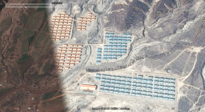
Recently updated satellite imagery shows part of North Korea’s new housing construction in Sonbong, where flash flooding in August caused widespread damage to homes and infrastructure.
The photos only show a section of the completed housing, though it does look relatively consistent withimages released by the Korean Central News Agency (KCNA) approximately one month after the flood.
Numerous KCNA and Korean Central Television (KCTV) articles showed the large-scale project throughout its construction, with large numbers of military personnel apparently drafted to help with the building work.
“The North uses military units as an organized labor force for various purposes including construction projects and agriculture” NK News intelligence director John Grisafi said.
“North Korea has a proportionately very large military and the economic system is state managed and so there is little to no distinction between what the government does and does not do in that regard,” he added.
The new housing is located just to the North of the Sonbong area, and is visible in satellite imagery from November though some smaller structures to the east of the new houses also appear to have been cleared in the intervening month.
KCNA claimed more than 1,800 new homes had been built in the region, though this is difficult to confirm with the new satellite imagery, which currently only shows the northern-most houses. The November photo shows approximately 150 new buildings, though none of the greenery visible in some of the later photos from DPRK media.
Another large construction project has also been carried out slightly to the south, though it is difficult to tell exactly when it occurred, with the next previous image of the area dating back to 2013.
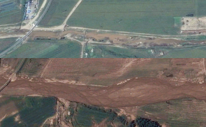
The river in 2013 (top) and 2015 (bottom). Image: Google Earth
Satellite photos of the area taken roughly two weeks after the floods show the size of the river compared to those taken in the same month two weeks previously.
In the most recent images the river appears to have burst its banks and is many times larger than in September 2013.
The area was last featured by KCNA when North Korean Kim Jong Un visited the reportedly finished construction.
Featured image: Google Earth
No comments:
Post a Comment